
Accurate positioning is crucial to modern surveying of land, construction mapping and infrastructure construction projects. A DGPS survey instrument assists surveyors gather precise location information using satellite signals and correction information. In comparison to standard GPS position, DGPS can provide improved precision for professional surveying applications.
Modern DGPS equipment for surveying is widely used for land surveying topographic mapping and construction layout roads projects GIS information collection and development of infrastructure. This guide will explain the basics of what DGPS is, what it is, how it operates and what it can do, the benefits, application and tips for selecting the appropriate equipment.
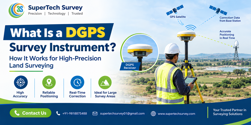
What Is a DGPS Survey Instrument?
The DGPS survey device is an instrument based on satellites. It’s a position system that can be used to calculate precise geographical coordinates. DGPS is a shorthand for Differential Global Positioning System.
A professional DGPS system typically includes a receiver antenna, the controller and surveying program and a correction source. Correction data can help reduce errors in satellite-based position and allows for more accurate field measurements.
Modern receivers can also be compatible with RTK technology and are therefore suitable for high-precision surveying and real-time positioning.
How Does DGPS Work?
DGPS enhances accuracy of positioning through the use of correction information from the reference station or correction network.
The most basic procedure is:
- The satellite signals can be received The receiver receives signals from satellites available for navigation.
- Calculating errors in position using a reference station. the location of a particular point can detect any errors in the satellite’s position.
- Data for corrections are sent Corrections are transmitted to the rover via wireless radios, the mobile Internet or through a correction network.
- The precise coordinates of the satellite are determined The rover uses the corrections to calculate an exact location.
This permits surveyors to collect reliable coordinates right on the spot.
What Is DGPS RTK?
DGPS RTK combines differential correction and Real-Time Kinematic technology to offer high-quality positioning.
An RTK configuration usually comprises a base station, or correction network and the receiver for the rover. The rover is able to receive correction information in real-time and calculates its location with high precision.
DGPS RTK is particularly useful for:
- Surveys of boundary and land
- Construction layout
- Topographic surveys
- Railway and road projects
- GIS mapping
- Infrastructure development
In projects where accuracy and instant results are essential An RTK-enabled receiver will greatly improve the efficiency of surveying.
Benefits of DGPS Survey Equipment
Professional DGPS survey equipment has many advantages to modern surveyors.
High-Precision Positioning
Correction technology increases the accuracy of positioning in comparison to navigation receivers that are standalone.
Faster Fieldwork
Surveyors can gather coordinates quickly, which reduces the time needed for a variety of field activities.
Real-Time Results
Utilizing RTK technology, surveyors are able to see information about their position while working instead of awaiting lengthy post-processing.
Improved Productivity
Modern DGPS systems are able to help survey teams cover greater areas and complete their projects more quickly.
Multiple Applications
Professional DGPS machines can be utilized for mapping, surveying construction, GIS roads, and infrastructure projects.
Applications of DGPS Survey Instruments
Land Surveying
DGPS surveyors employ high-precision positioning equipment to perform surveying boundaries, development of land and other property-related measurements.
Topographic Surveys
DGPS equipment is able to collect precise elevation and coordinate information to create topographic maps.
Construction
Engineers and surveyors can make use of DGPS to position sites and layout, alignment and for infrastructure construction.
Roads and Railways
DGPS technology is able to support routing surveys, aligning work, and positioning for projects in transportation.
GIS and Mapping
Professionals can utilize DGPS technology to gather accurate data on the geography of GIS databases and maps.
Alpha Geo DGPS for Professional Surveying
Alpha Geo DGPS solutions can be utilized by surveyors and engineers who require precise satellite-based positioning.
When choosing one of the Alpha Geo DGPS system, be aware of factors such as:
- Needed accuracy
- RTK capability
- Satellite constellation support
- Options for communication
- Software and Controller compatibility
- Battery life
- Field operating conditions
The correct configuration must meet the particular needs of your project in surveying.
How to Choose the Right DGPS Survey Instrument
Before you purchase an DGPS system, you should consider the following aspects:
Accuracy: Determine what level of precision needed in your work.
RTK Support If you require real-time high-precision positioning in real time, you should choose an RTK-capable device.
Satellite Service: Receivers with multiple constellations are able to improve the availability of satellites across a range of settings.
Software Compatibility: Check that the receiver is compatible using your field software for data collection and surveying.
Battery Durability and Battery Life For outdoor surveying, you need equipment that is able to withstand field conditions and last for long durations.
Technical Support Training Warranty, calibration, and after-sales support is important when investing in high-end equipment.
DGPS Price in India
The DGPS cost in India is contingent on the specifications of the receiver. RTK capability control of satellite accessories, software, and technical assistance.
Instead of comparing the equipment solely on price, buyers should take a look at the entire solution and its suitability to their requirements for surveying. For precise pricing it is recommended to seek out a professional provider with the specifications of your project.
Why Choose a Reliable DGPS Supplier?
The choice of the right DGPS supplier is just as crucial as selecting the equipment itself. A reputable provider can assist in the selection of products and configuration, technical assistance, training and after-sales support.
SuperTech Survey provides professional surveying solutions for engineers, surveyors, construction companies, surveyors and professionals in infrastructure. The company provides surveying tools that are designed to suit various fields and project needs.
Frequently Asked Questions
What is a DGPS questionnaire?
The DGPS Survey instrument can be described as a satellite-based position device that makes use of differential correction data to increase the accuracy of surveys and map-making.
What are the benefits of DGPS RTK improving accuracy?
DGPS RTK uses real-time correction information from an error correction station or base station network to calculate a very precise location.
What exactly is a DGPS machine employed to do?
A DGPS machine is suitable to survey land topographic mapping, construction layout, GIS data collection, road surveys, and infrastructure projects.
Which is the DGPS cost in India?
The DGPS cost in India is dependent on the model of receiver, RTK capability, software accessories, and other specifications.
Who is using DGPS Survey equipment?
Professional surveyors, civil engineers, construction firms, GIS professionals, and infrastructure developers typically make use of DGPS devices for surveys.
How do I pick the most suitable DGPS supplier?
Choose a DGPS supplier who can provide the appropriate equipment, technical support and training, and a warranty and reliable after-sales service.
Conclusion
The DGPS tool for surveying is a crucial instrument for high-precision modern surveying on land. By combining satellite position with the correction information, DGPS technology helps surveyors to achieve precise results while increasing fieldwork efficiency.
DGPS RTK, Alpha Geo DGPS and more modern DGPS survey equipment be used to support a range of uses, from topographic and land surveys to construction GIS roads, construction, and infrastructure projects.
When choosing a piece of equipment, take into consideration the accuracy, RTK capability, software compatibility, durability and the overall DGPS cost in India. For expert surveying solutions and professional advice, SuperTech Survey can help you select the best equipment for the requirements of your particular project.