In today’s rapidly developing infrastructure and construction industry, accurate surveying is the foundation of successful project planning and execution. From land development and road construction to mapping, infrastructure and engineering projects, reliable survey data plays a critical role in making informed decisions.
Supertech Survey & Services Pvt. Ltd. is a professional surveying solutions company providing surveying instruments, geospatial equipment, surveying services, technical support and after-sales assistance to professionals across India.
Established in 2014 in Noida, Supertech has developed its presence in the surveying and geospatial equipment sector, offering products such as GNSS receivers, Total Stations, Auto Levels, surveying accessories and advanced geospatial technologies.
Advanced Surveying Equipment for Modern Professionals
Modern surveying requires more than conventional instruments. Surveyors increasingly depend on high-precision GNSS, advanced Total Stations, LiDAR technology and digital surveying solutions to improve productivity and accuracy.
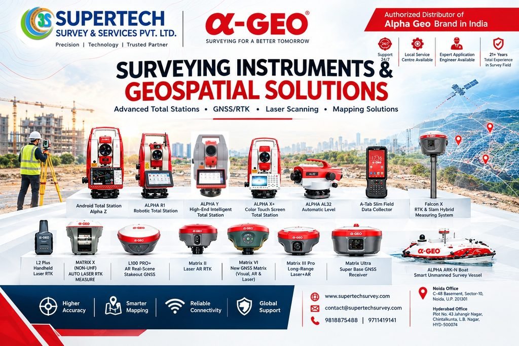
Supertech provides a range of surveying and geospatial equipment, including:
- GNSS / RTK Receivers
- DGPS Surveying Equipment
- Total Stations
- Robotic Total Stations
- Auto Levels
- Digital Levels
- Theodolites
- LiDAR & Handheld Laser Scanners
- Surveying Accessories
- Survey Data Controllers
- Monitoring Systems
- Hydrographic Survey Equipment
- Underground Cable & Pipeline Detection Equipment
The company’s product portfolio is designed to support applications ranging from land surveying and construction to mapping, infrastructure development and other specialized surveying requirements.
Authorized ALPHA GEO Distributor in India
One of Supertech’s important offerings is its association with ALPHA GEO surveying technology. Supertech identifies itself as an authorized distributor of ALPHA GEO products in India, providing access to modern GNSS and surveying solutions.
ALPHA GEO solutions include advanced GNSS receivers and innovative technologies designed for modern surveying workflows. Products such as the MATRIX series integrate technologies such as GNSS positioning, IMU, laser measurement and AR-based surveying features.
These technologies can help survey professionals improve field productivity, particularly when working in challenging or complex environments.
Professional Surveying Services
Equipment is only one part of a successful surveying project. Proper field execution, measurement techniques, data collection and technical expertise are equally important.
Supertech provides a range of surveying services, including:
- DGPS Surveying
DGPS surveying uses satellite positioning technology to determine locations with high precision. It is widely used for mapping, land development, infrastructure projects and engineering applications. - Land Surveying
Land surveying helps determine the position, dimensions and boundaries of land parcels. Accurate land survey data is important for planning, construction and property-related applications. - Topographic Surveying
Topographic surveys capture natural and man-made features of a site, including elevations, structures, roads and other physical elements. The resulting data can support engineering design and project planning. - Building Layout Services
Accurate construction layout is essential for transferring engineering designs to the actual construction site. Surveying equipment such as Total Stations and GNSS systems can help professionals establish accurate points and reference locations. - Road & Highway Surveying
Surveying is an important part of road and highway development. Route surveys, topographic surveys and construction setting-out activities provide essential information for infrastructure projects. - Drone & Digital Surveying
Modern digital surveying combines technologies such as UAVs, GNSS, laser scanning and mapping software to collect and process large amounts of spatial information efficiently.
Repair, Calibration & Technical Support
Professional surveying instruments require regular inspection, maintenance and calibration to maintain measurement performance.
Supertech also provides support related to survey instrument repair, calibration and after-sales services, helping customers maintain their equipment and reduce operational interruptions.
The company also highlights local service support, technical assistance and application-engineer support as part of its customer service approach.
Supporting Surveyors Across Different Industries
Surveying technology is used across a wide variety of industries. Supertech’s equipment and services can support applications such as:
- Construction & Building Projects
- Land Development
- Roads & Highways
- Railways
- Infrastructure Development
- Topographic Mapping
- Pipeline Projects
- Agriculture
- Mining & Engineering
- GIS & Geospatial Mapping
- Hydrographic Surveying
- Industrial Surveying
The company’s listed services include land, marine, pipeline, topographic, highway, railway, digital land and building-related surveying applications.
Why Choose Supertech Survey & Services?
Choosing the right surveying partner is important because equipment performance, technical support and service availability can directly affect field operations.
Supertech focuses on several key areas:
- Technology: Access to modern surveying and geospatial equipment.
- Product Range: Solutions covering GNSS, Total Stations, Auto Levels, scanners and other surveying equipment.
- Technical Assistance: Support for equipment selection, application and field requirements.
- Service Support: Repair, calibration and after-sales assistance.
- Industry Experience: The company states that its team brings extensive experience in the surveying field.
Looking Toward the Future of Surveying
The surveying industry is moving toward increasingly integrated technologies. GNSS, IMU, LiDAR, laser measurement, AR, digital mapping and cloud-based workflows are changing how professionals collect and use spatial data.
Supertech Survey & Services Pvt. Ltd. aims to participate in this transformation by providing surveying professionals with modern instruments, technical expertise and service support.
For surveyors, engineers, contractors, infrastructure companies and geospatial professionals, having a dependable equipment and service partner can make field operations more organized and efficient.
Conclusion
Supertech Survey & Services Pvt. Ltd. brings together surveying equipment, geospatial technology, professional surveying services and technical support under one platform.
From GNSS and DGPS receivers to Total Stations, Auto Levels, LiDAR scanners and specialized surveying solutions, the company provides options for professionals working across construction, infrastructure, mapping and engineering applications.
As surveying technology continues to evolve, Supertech’s focus on modern equipment, technical support and customer service positions it to serve the changing requirements of today’s surveying professionals.