


DGPS Surveyors
Supertech Survey & Services Pvt. Ltd. provide a DGPS surveying is a highly accurate navigation system using signals from satellites to determine a location.

Land Surveyors
Land surveying is the detailed study or inspection, as by gathering information through observations, measurements in the field, questionnaires, or research of legal instruments, and data analysis in the support of planning, designing, and establishing of property boundaries.
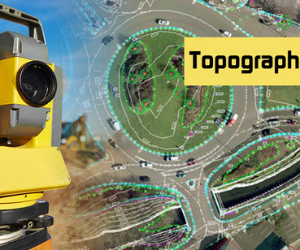
Topographic surveying
A geographical review finds all surface provisions of a property, and portrays every regular component and rises. Basically it is a 3-dimensional guide of a 3-dimensional property showing all normal and man-made provisions and enhancements. In particular, it shows their area, size, tallness and any progressions in height.
Traffic Surveyors
Traffic surveys aim to capture data that accurately reflects the real-world traffic situation in the area. It may be counting the number of vehicles using a road or collecting journey time information for example, but there are many other types of data that traffic surveys collect.

Building Surveyors
Building assessors are liable for evaluating the nature of structures, from houses to public and business properties. They inspect the state of structures and prompt on approaches to further develop them.
Topographic surveying
A geographical review finds all surface provisions of a property, and portrays every regular component and rises. Basically it is a 3-dimensional guide of a 3-dimensional property showing all normal and man-made provisions and enhancements. In particular, it shows their area, size, tallness and any progressions in height.

Building Layout Services
Efficient, reliable, and accurate construction layout is vital to the success of any size construction project. Supertech Survey & services Pvt. Ltd. Pacific layout services provide the contractor with detailed locations needed to accurately construct buildings and improvements. Utilizing Trimble Robotic Total Station, GPS, and our highly trained staff we can cater to the specific needs of the GC/CM.

Drone Surveyors
Supertech Survey & services Pvt. Ltd. is a leading platform based drone survey & inspection company in India. We automate manual processes to make your operations and maintenance tasks efficient, expedient and economical.

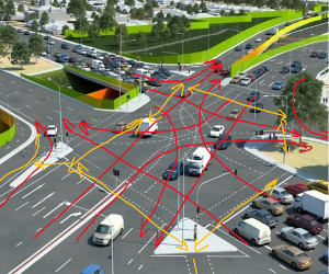
Highway Surveyors
In present modern era roads and highways plays a dominant role for transportation. The perfect and smooth roads and highways form the backbone for the better economy, and providing necessary links to vast rural areas across the country.

CAD Services
Supertech Survey & services Pvt. Ltd. provide CAD based Architecture Plans, Engineering Designs & 3D Models on multiple CAD softwares like Autocad and Revit Architecture.
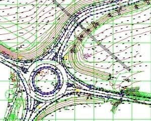
Road Topography Surveyors
We are represented considerable authority in the field of Carrying out nitty gritty Topographical Survey, Detailed Route Survey for Pipe Lines, Tunnel Survey, Road study, Track Geometry Survey, (Pre and Post Tamping), water system review, Construction Setting Out, Soil Resistivity Survey And Cadastral Survey, Setting Outs Job For Infrastructure Development Works.

Digital Land Surveyors
The technique of determining the terrestrial or three-dimensional positions of points and distances and angles between them with the help of laser scanning, UAV (Unmanned Aerial Vehicle), GPS (Global Positioning Satellite), and mapping software is called a digital land survey.
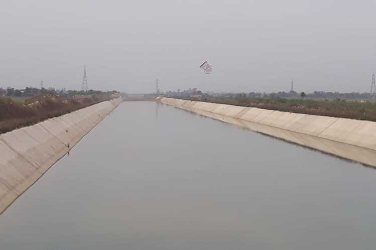
Canal Surveyors
Canals are waterways channels, or artificial waterways, for water conveyance, or to service. Supertech Survey & Services Pvt. Ltd.

Railway Surveyors
Survey is part of the asset life cycle of a railway. Surveyors collect the raw data, ensure the spatial model of the design is correct, provides oversight in the construction phase, checks build compliance and provides a final spatial model. Ongoing track monitoring may also be required.