NetBOX2

As big as your pocket

NetBOX2 is a brand new GNSS device with 1408 channels. It is small, but it is equipped with all required connectivity modules.

L300

GNSS RTK Receiver

L300 is a compact new generation of smart GNSS receiver designed for surveying project using the latest GNSS technology.

Overview

Multi constellation
L300 with its 1408 channels new generation full GNSS chipset & ability to support multiple satellite constellation including GPS, GLONASS, BEIDOU, GALILEO, QZSS, SBAS and IRNSS provides precise and accurate spatial data for all users around the world.

WiFi and WebUl
L300 serves as a WIFI hotspot, so users can easily access, manage the status, set the configuration or download static and PPK raw data through advanced WebUl using computer, smartphone or other electronic devices with WIFI support without any need to third party software or cable.

IMU Tilt Sensor
L300 is equipped with a fast initialization, calibration free & immune to magnetic interference Inertial Measurement Unit (IMU). All users can use this technology to collect or stakeout topo points up to 60°.

GSM & UHF radio
A fast internet connection is guaranteed with a built-in 4G module that accelerate receiving correction data using all telecommunication signals and bands. L300 comes with an integrated Tx/Rx internal UHF radio that ranges from 410 MHz to 470 MHz with selectable frequency providing ability to connect and collect accurate real time data in Base/Rover mode.

Battery & Power
L300 is delivered with an internal large capacity 6800mAh lithium-ion internal battery supporting USB type-C fast charging which allows users to work for more than 9 hours in daily field work.

1P67
Choosing a small, light but professional, rugged GNSS receiver has always been a concern among professional surveyors. L300 with its high quality magnesium alloy body provides such advantages without decreasing quality or notable increase in price.

Working mode
Every surveyor needs to operate and choose suitable working method based on project requirements and required accuracy. In order to work in such condition, users need a device to be able to work in different modes such as Static, Network RTK, UHF RTK, PPK & etc. L300 is offering all you need in one package…

Download

L300 Datasheet

1 file(s) 2 MB

Specification

Model

L300

GNSS Performance

Satellites Tracking

GPS: L1 C/A, L2C, L2P, L5

GLONASS: L1C/A, L1P, L2 C/A, L2P

BEIDOU: B1, B2, B3, B1C, B2a, B2b

GALILEO: E1, E5a, E5b

SBAS: WAAS, EGNOS, MSAS, GAGAN, SDCM

IRNSS: L5

QZSS: L1,L2C,L5

Channels

1408

Cold Start

< 60 seconds

Hot Start

< 15 seconds

RTK Signal Initialization

< 10 seconds

Initialization Reliability

> 99.9%

Time Accuracy

20 ns

Update Rate

1Hz – 20Hz

High precision static

H: 2.5 mm + 0.5 ppm

V: 5 mm + 0.5 ppm

RTK

H: 8 mm + 0.5 ppm

V: 15 mm + 0.5 ppm

NetBOX2

GNSS RTK Receiver

  • 1408 channels new generation full GNSS chipset
  • Supports multi-satellite constellation 
  • Fast initialization, calibration-free tilt sensor(IMU)
  • built-in 4G module
  • Integrated Tx/Rx internal UHF radio
  • WebUI for easy configuration and management

Overview

Multi Constellations

NetBOX2 with its 1408 channels new generation full GNSS chipset & ability to support multi satellite constellation including GPS, GLONASS, BEIDOU, GALILEO, QZSS, SBAS and IRNSS provides precise and accurate spatial data for all users around the world.


IMU Tilt Sensor

It is equipped with a fast initialization, calibration free & immune to magnetic interference Inertial Measurement Unit(IMU). All users can use this technology to collect or stakeout topo points up to 60°.


GSM & UHF Radio

A fast internet connection is guaranteed with a built-in 4G module that accelerate receiving corrections data using all telecommunication signals and bands. NetBOX2 comes with an integrated Rx internal UHF radio that ranges from 410MHz to 470MHz with selectable frequency providing ability to connect and collect accurate real time data in Rover mode.


Battery & Power

NetBOX2 is delivered with internal large capacity Lithium-ion battery supporting USB type-C fast charging which allows users to work for more than 14 hours in daily field work.

Download

NetBOX2 Datasheet

1 file(s) 3.91 MB

Specification

Model

NetBOX2

GNSS Performance

Satellites Tracking

GPS: L1 C/A, L2C, L2P, L5

GLONASS: L1C/A, L1P, L2 C/A, L2P

BEIDOU: B1, B2, B3, B1C, B2a, B2b

GALILEO: E1, E5a, E5b

SBAS: WAAS, EGNOS, MSAS, GAGAN, SDCM

IRNSS: L5

QZSS: L1,L2C,L5

Channels

1408

Cold Start

< 60 seconds

Hot Start

< 15 seconds

RTK Signal Initialization

< 5 seconds

Initialization Reliability

> 99.9%

GeoPuls

Handheld Laser RTK

GeoPuls is a brand-new RTK instrument with laser function. Its appearance is bold and innovative, and its performance is excellent. Based on the experience of the previous generation of laser equipment, we have made more improvements, including no more frequent calibration, and the use of green laser to solve the problem of difficult to aim in bright light. In a real sense, it realizes measure where you aim, and replacing the pole in the traditional measurement method. However, we are also compatible with the pole mode, which allows the laser measurement to be used even when the pole is used.GeoPuls is a product that surveyors really need.

Overview

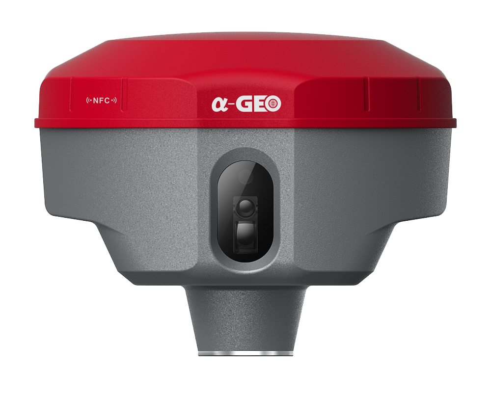
Military-level technology

Military-level processing technology, complete electromagnetic compatibility and shielding technology, minimize system electromagnetic interference, and ensure high-quality

observation data and results.

Multi constellation

GeoPuls with its 1408 channels new generation full GNSS chipset ability to support multiple satellite constellation including GPS, GLONASS, BEIDOU, GALILEO, OZSS,SBAS and IRNSS provides precise and accurate spatial data for all users around the world.
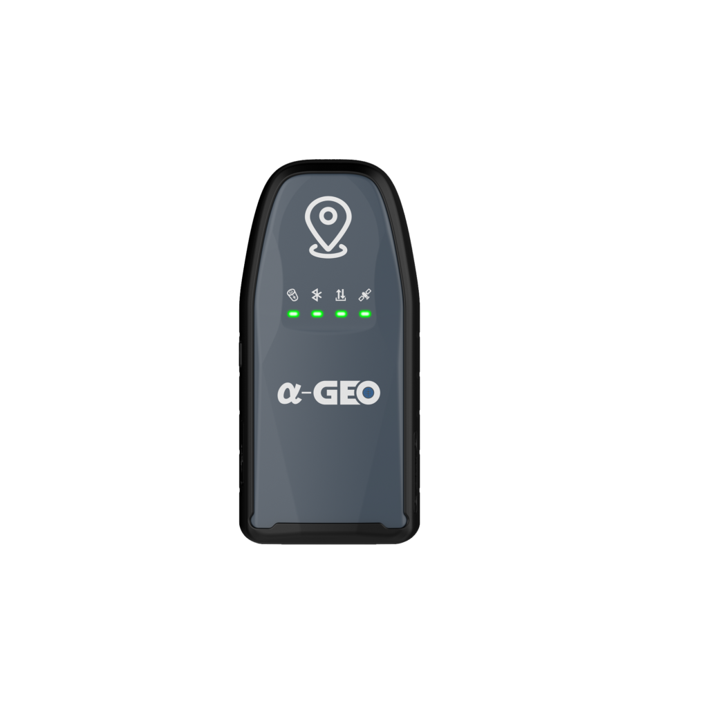
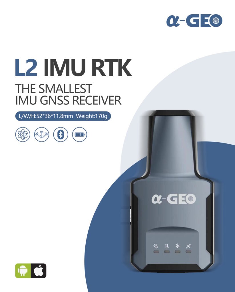
IMU Tilt Sensor

GeoPuls is equipped with a fast initialization,calibration free and immune to magnetic interference inertial Measurement Unit (IMU). All users can use this technology to collect or stakeout topo points

up to 120°.

Laser Surveying

The world’s exclusive patented laser coordinate measurement quick calibration technology can easily achieve centimeter-level measurement accuracy,

making measurement more accurate and user-friendly. Besides the green laser module used in the equipment overcomes the difficulty of aiming under sunlight, making field measurement operations faster and more efficient.

Dual-mode Bluetooth

It supports Basic Rate and Enhanced Data Rate operation of traditional Bluetooth, and also supports the latest low-power standard, dual-mode industrial-grade high-speed SPP3.0+ble5.0, suitable for Android/ISO/PC.

GSM

A fast internet connection is guaranteed with a built in 4G module that accelerate receiving correction data using all telecommunication signals and bands.

IP67

Strictly measured IP67 waterproof and dustproof grade, sturdy and durable, completely suitable for harsh outdoor environments.

Download

GeoPuls Datasheet

1 file(s) 5.18 MB

Specification

Model

GeoPuls


Performance Specification


Satellite signals tracked simultaneously

GPS: L1 C/A, L2C, L2P, L5


GLONASS: L1, L2


BEIDOU: B1, B2, B3, B1C, B2a, B2b


GALILEO: EI/E5a/E5b/E6


QZSS: L1/L2/L5/L6


SBAS: WAAS, EGNOS, MSAS, GAGAN, SDCM


Channels

1408 channels


Cold start

<60 s


Hot start

<15 s


Positioning output rate

1Hz-50Hz


Signal Reacquisition

<15


RTK Initialization time

<5s


Initialization Reliability

>99.99%


Time accuracy

20 ns


Positioning


Static GNSS surveying

Horizontal ±(2.5mm + 0.5ppm)
Vertical ±(5mm + 0.5ppm)


RTK surveying

Horizontal ±(8mm + 1.0ppm)
Vertical ±(15mm + 1.0ppm)


Laser surveying

±1cm +5mm/m

L2

The Smallest Geodetic GNSS Receiver in the World

  • Small and lightweight design
  • High performance
  • Fast initialization
  • Calibration-free IMU
  • Compatibility with a variety of GNSS software platforms

Overview

The L2 is a lightweight and compact GNSS receiver with IMU, making it ideal for a variety of surveying and mapping applications. It is the smallest geodesic GNSS device in the world so far, with a weight of less than 170g.


Despite its size, the L2 is fully equipped with all the necessary components, including a high-performance OEM board and 1408 channels. This allows it to support all satellites and frequency bands, and to perform exceptionally well even in complex environments.


The L2 also features a fast initialization, calibration-free, and immune to magnetic interference IMU module. This allows users to collect or stakeout topo points up to 60 degrees, without the need for any additional calibration.


The L2 is compatible with a variety of GNSS software platforms, such as SurPro, Field Genius, and SurvCE. This makes it easy to integrate into existing workflows.


The L2 is a versatile and powerful GNSS receiver that is well-suited for a wide range of applications, including:


  •     Land surveying
  •     GIS industry
  •     Pipeline measurement
  •     Construction
  •     Agriculture
  •     Mining
  •     Forestry
 

Download

L2 Datasheet

1 file(s) 6.29 MB

Specification

Model

L2

GNSS Performance

Satellites Tracking

GPS: L1 C/A, L2C, L2P, L5

GLONASS: L1C/A, L1P, L2 C/A, L2P

BEIDOU: B1, B2, B3, B1C, B2a, B2b

GALILEO: E1, E5a, E5b

SBAS: WAAS, EGNOS, MSAS, GAGAN, SDCM

IRNSS: L5

QZSS: L1,L2C,L5

Channels

1408

Cold Start

< 30 seconds

Hot Start

< 3 seconds

RTK Signal Initialization

< 10 seconds

Initialization Reliability

> 99.9%

Speed

0.03m/s

Update Rate

1Hz – 20Hz

RTK

H: 8 mm + 1 ppm

V: 15 mm + 1 ppm

L1

High-Precision GNSS Receiver

  • Full Constellation
  • Multi-Frequency
  • Advanced Bluetooth module with long range
  • Built-in receiving UHF Radio modem
  • IMU Tilt Sensor

Overview

Specification

Download

L1 Datasheet

1 file(s) 597.18 KB

NetBOX1

A mini portable multi-functional GNSS receiver

NetBOX1 is a mini portable multi-functional GNSS receiver, with a new generation of algorithm engine, Linux system, tilt survey, built-in 4G all Netcom, and Bluetooth/Wi-Fi.

Overview

NetBOX1 is a mini portable multi-functional GNSS receiver, with a new generation of algorithm engine, Linux system, tilt survey, built-in 4G all Netcom, and Bluetooth/Wi-Fi. It adopts a new appearance design, the magnesium alloy structure, and a highly integrated module design. It is a perfectly multifunctional compact GNSS receiver.


KEY FEATURES

Linux Intelligent System

Linux+Qualcomm MDM9628 Cortex-A7 intelligent system platform brings users efficient computing and unlimited expansion of product functions.

All Constellation and All Frequency GNSS Receiver

The host integrates a high-precision positioning module and supports BDS B1 / B2 / B3, GPS L1 / L2 / L5, GLONASS L1 / L2, Galileo E1 / E5A / e5b, SBAS L1, QZSS L1 / L2 / L5, and all frequency point signal reception and calculation of the whole system.

Tilt Survey

Built-in intelligent high-precision inertial navigation module, real-time tilt compensation, let RTK measurement say goodbye to “flying point”.


4G

The 4G full Netcom solution based on the Linux platform fully supports all telecommunications which have stronger signal and a more stable connection.


Combination Antenna

The new four-in-one antenna, which integrates GNSS, WiFi, Bluetooth, and 4G, has a smaller volume and better signal.

Super Long Endurance

The built-in large-capacity lithium battery ensures a continuous working time of more than 9 hours under normal operation.

Download

NetBOX1 Datasheet

1 file(s) 2.99 MB

Specification

Model

NetBOX1

GNSS Performance

Satellites Tracking

GPS: L1 C/A, L2C, L2P, L5

GLONASS: L1C/A, L1P, L2 C/A, L2P

BEIDOU: B1, B2, B3, B1C, B2a, B2b

GALILEO: E1, E5a, E5b

SBAS: WAAS, EGNOS, MSAS, GAGAN, SDCM

IRNSS: L5

QZSS: L1,L2C,L5

Channels

432

RTK Signal Initialization

< 10 seconds

Initialization Reliability

> 99.9%

Update Rate

1Hz – 20Hz

High precision static

H: 2.5 mm + 1 ppm

V: 5 mm + 1 ppm

RTK

H: 8 mm + 1 ppm

V: 15 mm + 1 ppm

Code differential

H: 0.25 m + 1 ppm

V: 0.5 m + 1 ppm

SBAS

H: 0.3 m

V: 0.6 m