
Modern surveying requires precision, efficiency, and reliable technology to handle challenging field conditions. Surveyors often face difficulties measuring ground points, building corners, walls, facades, and elevated targets that are not easy to access using conventional surveying methods.
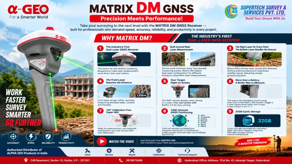
The Alpha Geo MATRIX DM Dual-Laser GNSS Receiver is designed to address these challenges with an innovative dual-laser measurement system. Combining GNSS positioning, laser measurement, camera-assisted aiming, and advanced IMU tilt compensation, the MATRIX DM offers a practical solution for modern surveying professionals.
Supertech Survey & Services Pvt. Ltd. is an authorized distributor of Alpha Geo products in India, helping surveying professionals access advanced geospatial equipment and technical support.
What Makes the Alpha Geo MATRIX DM Different?
The MATRIX DM features two laser modules designed for different measurement situations. Its bottom laser is intended for ground-point measurement, while the front-facing laser helps measure distant and difficult-to-reach targets.
This dual-laser design helps surveyors handle a wider range of field conditions without repeatedly changing their position or adopting awkward pole angles.
1. Innovative Dual-Laser Measurement Technology
The dual-laser system is the key feature of the MATRIX DM.
- Bottom laser: Designed for ground-point measurement while helping maintain a more upright antenna position.
- Front laser: Supports measurements of walls, corners, building facades, and other remote targets.
- Maximum front laser range: Up to 120 metres under specified conditions.
By providing two measurement options in one receiver, the MATRIX DM helps streamline surveying tasks and makes difficult points more accessible.
2. Integrated 5MP Camera for Laser Aiming
Finding a small laser dot on a target can be challenging, particularly in outdoor environments. The MATRIX DM incorporates a 5MP HD camera to display laser aiming on the controller or smartphone screen.
When used with the compatible SurPro 6.0 software and adjustable controller bracket, the camera-assisted workflow helps surveyors identify the intended target more conveniently.
This feature is particularly useful when working with distant targets or locations that are difficult to reach physically.
3. Advanced 1408-Channel GNSS Positioning
The MATRIX DM supports 1408-channel GNSS positioning and tracks signals from multiple satellite constellations, subject to satellite availability and supported frequencies.
Its GNSS capabilities are designed to support surveying workflows such as:
- Land and boundary surveying
- Construction site surveying
- Topographic data collection
- Road and infrastructure projects
- RTK surveying and positioning
- Static GNSS surveying
For more information about related equipment, explore our GNSS Receiver solutions and DGPS surveying solutions.
The brochure also lists fast RTK initialization and signal reacquisition capabilities. Actual positioning performance depends on satellite geometry, environmental conditions, correction data, and the selected surveying method.
4. 120° Calibration-Free Super IMU
Pole tilt can make field measurements more challenging, particularly when surveyors need to capture points from difficult positions.
The MATRIX DM includes a 120° calibration-free Super IMU tilt-compensation system. According to the brochure, it supports tilt measurement across a wide angle and is designed to help maintain positioning performance when the pole is tilted.
This capability can help surveyors collect points in situations where keeping the pole perfectly vertical is inconvenient.
5. Ergonomic Integrated Battery Grip
The MATRIX DM features an integrated battery grip designed around laser measurement operations.
Its controls include:
- One-click measurement
- Double-click switching between the two lasers
- Long-press laser power control
- A battery-level indicator
- Quick-release battery replacement
These features are designed to make measurement operations more convenient and support efficient fieldwork.
6. Reliable Battery Performance
The receiver uses a 7000mAh, 7.2V lithium-ion battery and supports USB Type-C fast charging.
The brochure specifies the following battery life under different operating modes:
- Rover mode: Up to 15 hours
- Base mode: Up to 9 hours
- Static mode: Up to 18 hours
Actual operating time may vary depending on working conditions, communication settings, and usage.
7. 32GB Cyclic Data Storage
The MATRIX DM includes 32GB of internal storage with cyclic recording. When the available storage is needed for new data, older stored data can be overwritten according to the device’s storage behaviour.
This feature supports extended field data collection while reducing the need for frequent manual storage management. Surveyors should still maintain suitable backups of important project data.
8. Built for Challenging Field Environments
The MATRIX DM is designed for demanding surveying applications. According to the brochure, its construction and environmental specifications include:
- IP67 water and dust protection
- Magnesium-alloy materials
- A stated 985g weight without the battery
- Operating temperature range of -40°C to +75°C
- Resistance to a 2-metre pole drop onto concrete under the stated test conditions
These specifications make it suitable for consideration in professional field surveying workflows, subject to the conditions and limitations specified by the manufacturer.
Applications of the Alpha Geo MATRIX DM
The combination of dual-laser measurement, GNSS positioning, camera-assisted aiming, and tilt compensation makes the MATRIX DM relevant to several surveying applications.
Land and boundary surveying: Collect GNSS survey points and work with ground targets.
Construction surveying: Support site measurement, layout, and positioning activities.
Building and facade measurement: Measure suitable walls, corners, and elevated targets using the front-facing laser.
Road and infrastructure surveys: Assist with field data collection for infrastructure-related projects.
Topographic surveying: Support the collection of location data across varied site conditions.
The appropriate measurement method and expected accuracy should always be selected according to project requirements and actual site conditions.
Why Choose Supertech Survey & Services Pvt. Ltd.?
Choosing suitable surveying equipment is only one part of a successful surveying workflow. Product guidance, application assistance, and after-sales support are also important considerations.
Supertech Survey & Services Pvt. Ltd. offers surveying and geospatial solutions for professionals across India and is an authorized distributor of Alpha Geo products in India.
Our support highlights include:
- Access to Alpha Geo surveying products
- Local service centre availability
- Technical and application assistance
- Support for surveying professionals
- Guidance on selecting suitable equipment for project requirements
Explore our complete surveying product list and surveying services to learn more about our solutions.
Our objective is to help surveying professionals identify practical technology for their fieldwork and project needs.
Conclusion
The Alpha Geo MATRIX DM Dual-Laser GNSS Receiver brings together two laser measurement options, a 5MP camera, 1408-channel GNSS positioning, 120° IMU tilt compensation, and 32GB cyclic storage in one surveying instrument.
Its dual-laser approach is especially relevant for professionals who regularly work with ground points and difficult-to-reach targets. By combining these capabilities, the MATRIX DM offers a versatile option for modern land surveying, construction, and infrastructure-related measurement tasks.
If you are looking for advanced GNSS and laser surveying equipment, contact Supertech Survey & Services Pvt. Ltd. to learn more about the Alpha Geo MATRIX DM and its suitability for your surveying requirements.
Contact Supertech Survey & Services Pvt. Ltd.
Authorized Distributor of Alpha Geo Products in India
- Phone: +91 9818875488
- Hyderabad Contact: +91 9711419141
- Email: contact@supertechsurvey.com
- Website: https://www.supertechsurvey.com
Noida Office: C-48 Basement, Sector-10, Noida, Uttar Pradesh – 201301
Hyderabad Office: Plot No. 43, Jahangir Nagar, Chintalkunta, L.B. Nagar, opposite Bharat Gas Godown, Hyderabad – 500074.
Contact our team for product information, application guidance, and surveying equipment enquiries.
Frequently Asked Questions (FAQs)
Q1. What is the Alpha Geo MATRIX DM GNSS Receiver?
The MATRIX DM is a GNSS surveying receiver that combines dual-laser measurement, camera-assisted laser aiming, and IMU tilt compensation.
Q2. What is the maximum front laser measurement range?
The brochure specifies a maximum front laser range of 120 metres. The achievable range depends on the target and environmental conditions.
Q3. Does the MATRIX DM support tilted-pole surveying?
Yes. It features a 120° calibration-free Super IMU tilt-compensation system.
Q4. Does the MATRIX DM have a built-in camera?
Yes. It includes a 5MP HD camera for laser-assisted aiming.
Q5. How much internal storage does the MATRIX DM offer?
The receiver provides 32GB of internal storage with cyclic recording.
Q6. Where can I enquire about the Alpha Geo MATRIX DM in India?
You can contact Supertech Survey & Services Pvt. Ltd. at +91 9818875488 or email contact@supertechsurvey.com.