
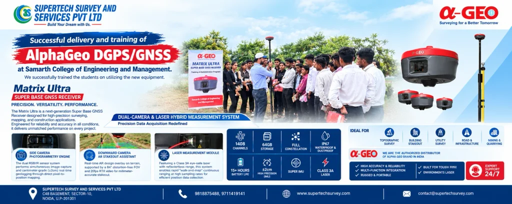
The AlphaGeo Matrix Ultra DGPS/GNSS Receiver is a professional surveying instrument designed for land surveying, construction stakeout, topographic mapping, and infrastructure projects. It combines GNSS positioning technology with dual-camera imaging, laser-assisted measurement, AR stakeout, and IMU tilt compensation to support modern surveying workflows.
With 1408 GNSS channels, 64 GB internal storage, an IP67-rated enclosure, and advertised battery life of over 15 hours, the AlphaGeo Matrix Ultra DGPS/GNSS Receiver is designed for demanding field applications. Its integrated measurement features can help surveying professionals collect spatial data and perform selected measurement tasks more efficiently.
In this guide, SuperTech Survey & Services Pvt. Ltd. explains the key features, technical specifications, applications, and buying considerations for the AlphaGeo Matrix Ultra DGPS/GNSS Receiver.
What Is the AlphaGeo Matrix Ultra DGPS/GNSS Receiver?
The AlphaGeo Matrix Ultra DGPS/GNSS Receiver is a surveying instrument designed to determine geographical coordinates and support professional field measurement tasks. GNSS technology uses satellite signals for positioning, while DGPS refers to differential positioning techniques that use corrections to improve positioning results.
The positioning accuracy achieved depends on the receiver configuration, correction method, satellite conditions, and survey environment. Buyers should confirm whether the particular Matrix Ultra configuration supports their required DGPS, RTK, base-station, or rover workflow.
SuperTech Survey & Services Pvt. Ltd., established in 2014 in Noida, provides surveying instruments, geospatial equipment, technical support, and after-sales assistance across India.
Key Features of the AlphaGeo Matrix Ultra DGPS/GNSS Receiver
1. 1408 GNSS Channels
The receiver features a 1408-channel GNSS engine designed to track signals from supported satellite constellations. Multi-constellation tracking can help maintain satellite availability in different field environments. Actual positioning accuracy also depends on satellite geometry, interference, obstructions, and correction data.
2. Dual-Camera and Laser Hybrid Measurement
The integrated dual-camera and laser system supports alternative measurement workflows when placing a surveying pole directly on a target is difficult. Depending on the target and operating conditions, these capabilities may help surveyors collect information around buildings, obstacles, and infrastructure features.
3. Side Camera Photogrammetry
The side camera supports image-based data collection and geotagging workflows. This can assist with visual documentation and spatial data capture. Users should verify image-positioning accuracy and workflow limitations against the manufacturer’s official specifications.
4. Downward Camera with AR Stakeout
The downward-facing camera supports Augmented Reality (AR) stakeout, providing visual guidance for locating planned design points. This feature can be useful for building layout, construction setting-out, and infrastructure projects where surveyors need to transfer design coordinates to the ground.
5. Class 3A Laser Measurement
The integrated Class 3A laser module is designed to support reflectorless measurement workflows for suitable targets. Laser range and measurement performance depend on target properties and operating conditions. Always abide by the laser safety guidelines provided by the manufacturer.
6. Super IMU Tilt Compensation
The product information advertises ±2 cm precision with Super IMU. Inertial Measurement Unit (IMU) technology supports tilt compensation, helping surveyors take measurements without keeping the pole perfectly vertical for every observation. Actual accuracy varies with the measurement method, calibration, correction service, and environment.
7. 64 GB Storage and 15+ Hours of Battery Life
The AlphaGeo Matrix Ultra DGPS/GNSS Receiver provides 64 GB of internal storage for survey observations and project files. Its advertised battery life exceeds 15 hours, although actual operating time depends on settings, temperature, and usage.
8. IP67 Dust and Water Protection
The advertised IP67 rating indicates protection against dust and temporary immersion under specified test conditions. This makes the receiver suitable for many outdoor surveying environments when operated according to the manufacturer’s guidelines.
AlphaGeo Matrix Ultra DGPS/GNSS Receiver Specifications
| Specification | Details |
| Product name | AlphaGeo Matrix Ultra DGPS/GNSS Receiver |
| Product type | Super Base GNSS Receiver |
| GNSS channels | 1408 |
| Measurement system | Dual-camera and laser hybrid |
| Camera technology | Side photogrammetry and downward AR camera |
| Laser module | Class 3A |
| Advertised precision | ±2 cm with Super IMU |
| Internal storage | 64 GB |
| Protection rating | IP67 |
| Advertised battery life | 15+ hours |
These requirements are derived from the product data that was provided. Confirm the official datasheet for supported constellations, correction methods, laser range, radio configuration, and accuracy by operating mode.
Applications of the AlphaGeo Matrix Ultra DGPS/GNSS Receiver
- Land and topographic surveying: Collect coordinates and field data for terrain mapping, site planning, and land development.
- Construction surveying: Support building layout, design-point marking, and construction stakeout using suitable positioning and AR workflows.
- Road and infrastructure projects: Assist with site mapping, alignment surveys, and engineering layout.
- Utility mapping: Record coordinates of visible utility infrastructure and site features. Underground utilities require suitable detection and verification methods.
- Mining and quarrying: Support terrain mapping, excavation surveys, and site measurements according to project requirements.
Benefits of Using the AlphaGeo Matrix Ultra DGPS/GNSS Receiver
The AlphaGeo Matrix Ultra DGPS/GNSS Receiver combines satellite positioning with camera-assisted and laser measurement features. Potential benefits include flexible measurement workflows, visual stakeout guidance, tilt-compensated observations, integrated data storage, and suitability for a range of outdoor surveying tasks.
Its practical value depends on the project’s accuracy requirements, correction availability, operator experience, and site conditions. Buyers should evaluate these factors before selecting the equipment.
How to Choose the Right DGPS/GNSS Receiver
Before purchasing the AlphaGeo Matrix Ultra DGPS/GNSS Receiver, consider the required positioning accuracy, compatibility with your data collector and software, correction services, base-and-rover configuration, laser measurement range, battery requirements, and after-sales support.
SuperTech Survey & Services Pvt. Ltd. helps customers explore surveying instruments and geospatial solutions for different project requirements. Contact the team to enquire about Matrix Ultra availability, configuration, accessories, warranty, and a product demonstration.
You can also explore the GNSS Receiver and Surveying Services pages on the SuperTech Survey website.
Frequently Asked Questions
1. What is the AlphaGeo Matrix Ultra DGPS/GNSS Receiver used for?
It is designed for professional surveying applications, including topographic mapping, construction stakeout, infrastructure surveys, and selected laser-assisted measurement tasks.
2. How many channels does the Matrix Ultra have?
The supplied product information lists 1408 GNSS channels for satellite signal tracking.
3. What is the advertised accuracy of the Matrix Ultra?
The supplied information advertises ±2 cm precision with Super IMU. Actual results depend on correction data, measurement mode, satellite conditions, and the working environment.
4. Does the receiver support AR stakeout?
Yes, the supplied product information describes a downward-facing camera for AR-assisted stakeout.
5. What is the battery life of the AlphaGeo Matrix Ultra?
The advertised battery life is over 15 hours. Actual operating time may vary with usage and environmental conditions.
6. How can I enquire about the AlphaGeo Matrix Ultra DGPS/GNSS Receiver price in India?
Contact SuperTech Survey & Services Pvt. Ltd. to request a quotation and confirm the available configuration, included accessories, warranty, and technical support.
Conclusion
The AlphaGeo Matrix Ultra DGPS/GNSS Receiver combines 1408-channel GNSS technology, dual-camera imaging, laser-assisted measurement, AR stakeout, and IMU tilt compensation. These features make it worth evaluating for land surveying, construction layout, topographic mapping, and infrastructure projects.
Before purchasing, verify the official technical specifications and ensure the receiver meets your positioning requirements. Contact SuperTech Survey for assistance in evaluating surveying equipment for your project.